Traffic and Travel: Closed roads - roads closed due to flooding and landslides - parts of Newry under water - full list of current road closures - main Dublin route reopened southbound
and live on Freeview channel 276
Scroll down for full details
The amber weather warning for rain expired at 9am this morning but a yellow warning remains in place until 12noon.

The next yellow warning starts at 9pm this evening running until 9am on Wednesday (November 1)
Advertisement
Hide AdAdvertisement
Hide AdA further yellow warning associated with Storm Ciaran starts at 6am on Thursday morning (November 2) running until midnight on the same day
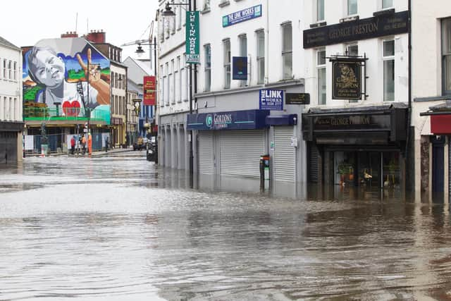
Parts of Newry in County Down are under water after the city's canal burst its banks on Monday.
Live travel updates for Northern Ireland on Tuesday October 31 2023
Roads Closed Updated
trafficwatchniFor motorists using the A1. The N1 just South of the border has been been reopened for South bound traffic at Junction 20 (turn off for Carrickdale Hotel). However, this is only passable with extreme care. The North bound carriageway of the N1 remains closed due to flooding.
Elsewhere the following road closures are in place.
Co Down
- Bangor - Ballysallagh Road has now reopened and is passable with care.
- Newry Road from Rathfriland Road Roundabout to Mayobridge closed due to flooding.
- Ferryhill Road, Newry closed due to a landslide.
- A2 Shore Road leaving Rostrevor closed due to a landslide. Local diversion in place.
- Mayobridge - Hilltown Road is impassable due to flooding between Maybridge and Hilltown
- Killowen - The A2 Killowen Road closed due to the possibility of landslips - Rostrevor to Kilkeel traffic will be diverted via Rostrevor – Hilltown – Kilcoo – Castlewellan – Newcastle - Kilkeel. Allow extra time for your journey.
- Scarva - The B3 Legananny Rd has been closed between the Old Mill Road and Lisnagade Road following damage to a bridge - Road users are advised to seek an alternative route for their journey
- Strangford :Black Causeway Road, Strangford has been closed due to flooding at a number of locations along the route.
- Moira - A26 Glenavy Road remains closed due to flooding leaving M1 Moira Road roundabout. Surrounding roads are also badly affected with flooding. Road users are advised to find an alternative route for their journey. International Airport traffic may want to consider using M1. A12 & M2 as an alternative route and allow extra time for their journey.
- Newry - Camlough Road / Newtown Road closed due to flooding. Road users are advised to find an alternative route for their journey.
- Newry – The A25 Rathfriland/Finnard Rd is closed between Shinn Straight and the Arddarragh crossroads due to severe flooding. Road users are advised to find an alternative route for their journey.
- Newry - Greenan Road, Poyntpass is closed from:- Rockmeeting Road to Blackridge Road. Please seek an alternative route for your journey. (20:26)
- Helens Bay - The Bridge Road South has been closed due to flooding - Please seek an alternative route for your journey.
- Ballynahinch - Drumgiven Road closed from Creevyargon Road to Cahard Road due to severe flooding. Please seek an alternative route for your journey.
- B2 Mullahead Road, Portadown - closed due to flooding.
- Brackagh Moss Road, Portadown - closed due to flooding.
- B3 Ballynaskeagh Road – Passable with care, verge collapsed at two separate locations. Being assessed, may require TTM/lights and closing of a lane to allow safe passage of traffic.
- A28 Killylead Rd, Armagh - RD Flooded Due to CALLAN RIVER Bursting it banks – RD Closed at Mullagrieve Pk
- Callenbridge Rd Armagh Flooded due to CALLAN RIVER Bursting its banks
- Cathedral rd Armagh - Passible with care – THIS would be the route traffic most likely to divert .
- Grange Blundel Rd closed at junction U7431 Ballyygassoon Rd. Callan River burst banks.
- Glenanne Rd (A28 Gosford Rd to B133 Bessbrook Rd) River Cusher burst banks.
- Castlewellan : Magheramayo road Flooding
- Aughnacloy : Rehaghey road : culvert colapse and road slip
- Comber : Quarry Road : Flooding
- Banbridge:- Riley street closed at the junction with Downshire Road at mini roudabout due to flooding. Please seek an alternative route for your journey.
Co Armagh
- A28 Killylea Road, Armagh closed due to a river bursting it banks. road closed at Mullacreevie Park.
- A51 Hamiltonsbawn Road, Tandragee closed due to flooding. Road closed at Cordrain Road junction.
- A3 Armagh to Portadown Road at Stonebridge Roundabout. Road flooded due to a river bursting its banks, but passable with care.
- Battlehill Road / Kilmore Road closed near Stonebridge Roundabout due to a river bursting its banks.
- Callanbridge Road / Armagh Road is closed due to a river bursting its banks.
- Cathedral Road, Armagh flooded, but passable with care.
- Mullahead Road, Portadown. Road closed due to the River Bann bursting its banks and overflowing.
- Ballcrummy Road, Armagh closed due to flooding
- Mullenure Lane, Armagh closed due to flooding
- Bolton Road outside Markethill Road closed due to flooding
- Ballyards Road, Millford. Closed due to flooding.
- Ballygassoon Rd at closed junction C183 Grange Blundel Rd. River Callan burst banks.
- Ballygassoon Rd at closed junction C183 Grange Blundel Rd. River Callan burst banks.
- Glenanne Rd (A28 Gosford Rd to B133 Bessbrook Rd) River Cusher burst banks.
- Ballyards Road closed - River Callan burst banks.
Other sites being checked and a significant number of other roads in the area are impacted but passable with care.
trafficwatchniFor motorists using the A1. The N1 just South of the border has been been reopened for South bound traffic at Junction 20 (turn off for Carrickdale Hotel). However, this is only passable with extreme care. The North bound carriageway of the N1 remains closed due to flooding.
Elsewhere the following road closures are in place.
Co Down
- Bangor - Ballysallagh Road is impassable due to flooding.
- Newry Road from Rathfriland Road Roundabout to Mayobridge closed due to flooding.
- Ferryhill Road, Newry closed due to a landslide.
- A2 Shore Road leaving Rostrevor closed due to a landslide. Local diversion in place.
- Mayobridge - Hilltown Road is impassable due to flooding between Maybridge and Hilltown
- Killowen - The A2 Killowen Road closed due to the possibility of landslips - Rostrevor to Kilkeel traffic will be diverted via Rostrevor – Hilltown – Kilcoo – Castlewellan – Newcastle - Kilkeel. Allow extra time for your journey.
- Scarva - The B3 Legananny Rd has been closed between the Old Mill Road and Lisnagade Road following damage to a bridge - Road users are advised to seek an alternative route for their journey
- Strangford :Black Causeway Road, Strangford has been closed due to flooding at a number of locations along the route.
- Moira - A26 Glenavy Road remains closed due to flooding leaving M1 Moira Road roundabout. Surrounding roads are also badly affected with flooding. Road users are advised to find an alternative route for their journey. International Airport traffic may want to consider using M1. A12 & M2 as an alternative route and allow extra time for their journey.
- Newry - Camlough Road / Newtown Road closed due to flooding. Road users are advised to find an alternative route for their journey.
- Newry – The A25 Rathfriland/Finnard Rd is closed between Shinn Straight and the Arddarragh crossroads due to severe flooding. Road users are advised to find an alternative route for their journey.
- Helens Bay - The Bridge Road South has been closed due to flooding - Please seek an alternative route for your journey.
- Ballynahinch - Drumgiven Road closed from Creevyargon Road to Cahard Road due to severe flooding. Please seek an alternative route for your journey.
Co Armagh
- A28 Killylea Road, Armagh closed due to a river bursting it banks. road closed at Mullacreevie Park.
- A51 Hamiltonsbawn Road, Tandragee closed due to flooding. Road closed at Cordrain Road junction.
- A3 Armagh to Portadown Road at Stonebridge Roundabout. Road flooded due to a river bursting its banks, but passable with care.
- Battlehill Road / Kilmore Road closed near Stonebridge Roundabout due to a river bursting its banks.
- Callanbridge Road / Armagh Road is closed due to a river bursting its banks.
- Cathedral Road, Armagh flooded, but passable with care.
- Mullahead Road, Portadown. Road closed due to the River Bann bursting its banks and overflowing.
- Ballcrummy Road, Armagh closed due to flooding
- Mullenure Lane, Armagh closed due to flooding
- Bolton Road outside Markethill Road closed due to flooding
- Ballyyards Road, Millford. Closed due to flooding.
trafficwatchniBetween 21:00 (UTC) on Tue 31 Oct 2023 and 09:00 (UTC) on Wed 1 Nov 2023
Another period of heavy rain is likely to bring some flooding and transport disruption across Northern Ireland.
What to expect
- Spray and flooding could lead to difficult driving conditions and some road closures
- Delays or cancellations to train and bus services are possible
- Homes and businesses could be flooded, causing damage to some buildings
- Some communities may be cut off by flooded roads
Further details
After a very brief respite, another spell of heavy rain is likely to move from the southwest later on Tuesday and at first on Wednesday. Many places will see another 15 to 25 mm, with 30-50 mm possible in the east, this falling on already very saturated ground.
Regions affected
· County Antrim
· County Armagh
· County Down
· County Fermanagh
· County Londonderry
· County Tyrone
Trafficwatch NIThe N1 just South of the border has been been reopened for South bound traffic at J20 (Carrickdale Hotel). However, this is only passable with extreme care. The North bound carriageway of the N1 remains closed due to flooding.
Closed Roads Update at 10:50
Co Down
- Bangor - Ballysallagh Road is impassable due to flooding.
- Newry Road from Rathfriland Road Roundabout to Mayobridge closed due to flooding.
- Ferryhill Road, Newry closed due to a landslide.
- A2 Shore Road leaving Rostrevor closed due to a landslide. Local diversion in place.
- Mayobridge - Hilltown Road is impassable due to flooding between Maybridge and Hilltown
- Killowen - The A2 Killowen Road closed due to the possibility of landslips - Rostrevor to Kilkeel traffic will be diverted via Rostrevor – Hilltown – Kilcoo – Castlewellan – Newcastle - Kilkeel. Allow extra time for your journey.
- Scrava - The B3 Legananny Rd has been closed between the Old Mill Road and Lisnagade Road following damage to a bridge - Road users are advised to seek an alternative route for their journey
- Strangford :Black Causeway Road, Strangford has been closed due to flooding at a number of locations along the route.
- Moira - A26 Glenavy Road remains closed due to flooding leaving M1 Moira Road roundabout. Surrounding roads are also badly affected with flooding. Road users are advised to find an alternative route for their journey. International Airport traffic may want to consider using M1. A12 & M2 as an alternative route and allow extra time for their journey.
- Newry - Camlough Road / Newtown Road closed due to flooding. Road users are advised to find an alternative route for their journey.
- Newry – The A25 Rathfriland/Finnard Rd is closed between Shinn Straight and the Arddarragh crossroads due to severe flooding. Road users are advised to find an alternative route for their journey.
- Helens Bay - The Bridge Road South has been closed due to flooding - Please seek an alternative route for your journey.
- Ballynahinch - Drumgiven Road closed from Creevyargon Road to Cahard Road due to severe flooding. Please seek an alternative route for your journey.
Co Armagh
- A28 Killylea Road, Armagh closed due to a river bursting it banks. road closed at Mullacreevie Park.
- A51 Hamiltonsbawn Road, Tandragee closed due to flooding. Road closed at Cordrain Road junction.
- A3 Armagh to Portadown Road at Stonebridge Roundabout. Road flooded due to a river bursting its banks, but passable with care.
- Battlehill Road / Kilmore Road closed near Stonebridge Roundabout due to a river bursting its banks.
- Callanbridge Road / Armagh Road is closed due to a river bursting its banks.
- Cathedral Road, Armagh flooded, but passable with care.
- Mullahead Road, Portadown. Road closed due to the River Bann bursting its banks and overflowing.
- Ballcrummy Road, Armagh closed due to flooding
- Mullenure Lane, Armagh closed due to flooding
- Bolton Road outside Markethill Road closed due to flooding
- Ballyyards Road, Millford. Closed due to flooding.
Co Antrim
- Ballygally – Contractor on site – But road remains closed for now.
- Tower Road junction with Coast Road approx. 6 miles from Carnlough – Road closed – Landslide
- Drumnageeragh Road, approx. 3 miles from Ballygally – Landslide


nidirectWeather warning for heavy rain still in place this morning. Travel disruption, dangerous driving conditions, flooding, fast-flowing or deep floodwater & loss of power & other essential services possible. Flooding Incident Line 0300 2000 100. https://nidirect.gov.uk/rain @deptinfra
Trafficwatch NIFor motorists travelling to or from Southern Ireland. Due to flooding the N1 has been closed in both directions at Junction 20 (turn off for Carrickdale Hotel). (09:43)
trafficwatchniFor motorists heading to Southern Ireland. Due to flooding the N1 has been closed in both directions at Junction 20 (turn off for Carrickdale Hotel).
Elsewhere the following road closures are in place.
Co Down
- Bangor - Ballysallagh Road is impassable due to flooding.
- Newry Road from Rathfriland Road Roundabout to Mayobridge closed due to flooding.
- Ferryhill Road, Newry closed due to a landslide.
- A2 Shore Road leaving Rostrevor closed due to a landslide. Local diversion in place.
- Mayobridge - Hilltown Road is impassable due to flooding between Maybridge and Hilltown
- Killowen - The A2 Killowen Road closed due to the possibility of landslips - Rostrevor to Kilkeel traffic will be diverted via Rostrevor – Hilltown – Kilcoo – Castlewellan – Newcastle - Kilkeel. Allow extra time for your journey.
- Scrava - The B3 Legananny Rd has been closed between the Old Mill Road and Lisnagade Road following damage to a bridge - Road users are advised to seek an alternative route for their journey
- Strangford :Black Causeway Road, Strangford has been closed due to flooding at a number of locations along the route.
- Moira - A26 Glenavy Road remains closed due to flooding leaving M1 Moira Road roundabout. Surrounding roads are also badly affected with flooding. Road users are advised to find an alternative route for their journey. International Airport traffic may want to consider using M1. A12 & M2 as an alternative route and allow extra time for their journey.
- Newry - Camlough Road / Newtown Road closed due to flooding. Road users are advised to find an alternative route for their journey.
- Newry – The A25 Rathfriland/Finnard Rd is closed between Shinn Straight and the Arddarragh crossroads due to severe flooding. Road users are advised to find an alternative route for their journey.
- Helens Bay - The Bridge Road South has been closed due to flooding - Please seek an alternative route for your journey.
- Ballynahinch - Drumgiven Road closed from Creevyargon Road to Cahard Road due to severe flooding. Please seek an alternative route for your journey.
Co Armagh
- Battlehill Road, Richill closed due to flooding between Dobbin Road and Kilomore Road.
- Armagh Road in Tandragee is closed due to flooding. Please seek an alternative route for your journey.
- Ballcrummy Road, Armagh closed due to flooding
- Mullenure Lane, Armagh closed due to flooding
- Bolton Road outside Markethill Road closed due to flooding
